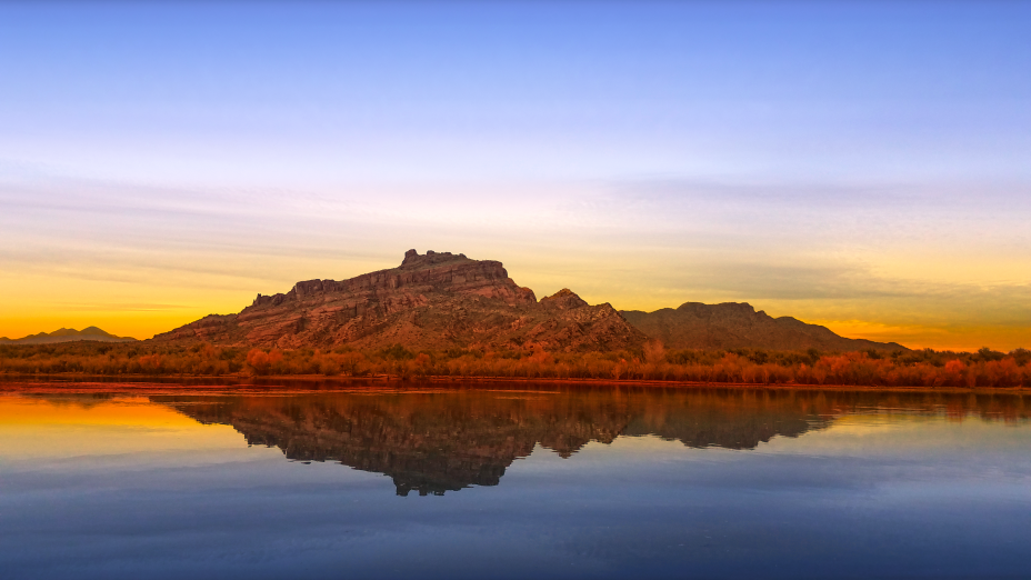
Red Mountain, often referred to as Mount McDowell, is located on the Salt River Pima-Maricopa Indian Reservation just north of Mesa, Arizona.
Red Mountain is composed of sandstone conglomerate, giving it a distinctive red color, especially notable during sunset. This coloration is why it’s also known as “Red Mountain” or “FireRock.” The mountain features a deep cleft on its western side, which is called “Gunsight” due to its resemblance to the narrow slot in a fortress used for firing at attackers.
Named after General Irvin McDowell, a Union officer from the Civil War, the mountain has been a landmark since its naming. It’s important to note that this Red Mountain is distinct from McDowell Peak, which is located 11 miles to the northwest.
The mountain is situated on tribal land, specifically the Salt River Pima-Maricopa Indian Reservation. Since the early 1980s, access to Red Mountain has been restricted to hikers, climbers, and photographers due to issues with vandalism. However, there are areas along the eastern side near Power Road/Bush Highway where one can view the mountain from a distance, and there’s a picnic area nearby which requires a Tonto Pass for use.
Despite being off-limits to the public, Red Mountain remains a striking feature in the Phoenix area landscape. Its photogenic qualities make it a well-known sight, although capturing it up close is not possible. The mountain’s red hue and unique geological features contribute to its local fame and visual appeal.
Red Mountain’s combination of geological uniqueness, historical naming, and cultural significance make it an intriguing subject, though its inaccessibility means its appreciation is mostly from afar.
Mount McDowell (O’odham: S-wegĭ Doʼag, Yavapai: Wi:kawatha), more commonly referred to as Red Mountain, is located on the Salt River Pima-Maricopa Indian Reservation, just north of Mesa, Arizona. It is named after General Irvin McDowell, a Union officer in the Civil War. Its elevation is 2,832 feet (863 m). It is not the same landmark as the McDowell Peak, which is 11 miles (18 km) away to the northwest.
Mount McDowell is often called “Red Mountain” or “FireRock”, due to its composition of sandstone conglomerate which gives it a distinctive red color that glows during sunset. The deep cleft on its western side (visible in the image at right) is known as “Gunsight” because of its resemblance to the narrow slot in a fort used for firing at attackers.[3]
The mountain is very photogenic but it’s difficult to photograph up close. The mountain is located on the Salt River Pima-Maricopa Indian Reservation, and has been declared off-limits to hikers, climbers and photographers since the early 1980s, due to vandalism.[4] The eastern side, along Power Road/Bush Highway, has areas where you can pull off the road, and there’s a picnic area just north of Granite Reef Dam (Tonto Pass required).
The western side of the mountain is along SR 87 (Beeline Highway), which is a busy four-lane road with narrow shoulders. There are several blocked roads onto the Salt River Indian Reservation, where you can pull off for a minute if the traffic is light.


